The QRRC is located in the Quesnel River Basin (QRB), one of several truly extraordinary watersheds in BC's Interior.
It is set –
- In the foothills of the wild and rugged Cariboo Mountains, the northern-most range of the Columbia Mountains, in the Omenica Belt;
- Amid the western fringes of the globally-unique Interior Temperate Rainforest: nowhere else on Earth is known to experience the same climatological combination of high moisture supply and temperature extremes (Arsenault and Goward, 1999);
- On the banks of the Quesnel River, one of BC's premier salmon rivers;
- At the outlet of Quesnel lake, thought to be the world's deepest fjord-lake: with an estimated (but as yet unverified) maximum depth of approximately 600 m, it may be among the ten deepest lakes on the planet;
- Among some of the few remaining tracts of land to host a full set of the ‘iconic’ species associated worldwide with Canadian mountain wilderness – grizzly bear, mountain caribou, cougar, lynx, wolf, wolverine and a variety of salmon (Craighead and Cross, 2008, also available as a full report);
- Near the northern limit of the traditional lands of the Secwepemc people, and southern part of those associated with the Dakelh (Lheidli T'enneh);
- Within the Cariboo Goldfields (~1865): the village of Likely is on the Gold Rush Trail from Lillooet to Barkerville. The centre is located close to the Bullion Pit Mine (which, at 1900 values, yielded $1,233,936 over 11 years) and the ‘ghost town’ of Quesnel Forks.
For scientists interested in links between landscape, ecology and climate, the watershed offers a transect from the relatively dry spruce forests of the Fraser Plateau, through the foothills of the Interior Cedar-Hemlock and Engelmann Spruce / Sub-Alpine Fir BEC Zones, to the uplands of the Cariboo Mountains, the 'water-towers' of the Upper Fraser Watershed, where extensive areas of ice still survive. Lakes and rivers, forests and range, lowlands and mountains are all to be found in close proximity.

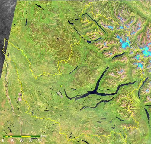
A false-colour image of the QRB taken by Landsat 8's
Operational Land Imager (OLI), on 19th August 2016.
The centre's location is marked by the yellow diamond.
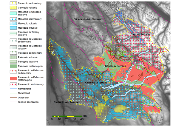
The QRB spans four of the fundamental units of BC's deep structural geology - from east to west, the Cariboo (Cassiar), Kootenay, Quesnellia and Cache Creek terranes. Sedimentary, volcanic, intrusive and metamorphic formations are represented from the Neo-Proterozoic (~1000 - 541 million years), through the Palaeozoic and Mesozoic, to the Cenozoic (see map). A list of all distinct units, together with brief descriptions, is available for download in Excel and Adobe Acrobat formats.
Along with forestry, agriculture and recreation, mining for a range of metals remains an important component of the area’s economy today. In August 2014, a breach of the tailings-pond dam at the Mount Polley mine released some 25 million cubic metres of slurry down Hazeltine Creek into Quesnel Lake: subsequent remediation work, and research into potential impacts on freshwater ecology and aquatic geochemistry, continue to be studied from the QRRC within a major project supported by the federal Environmental Damages Fund.
Information about the three main communities within the QRB is provided by the web-sites of Likely, Horsefly and Big Lake Ranch. Williams Lake is the nearest city to offer a more extensive range of services.
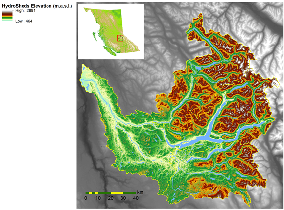
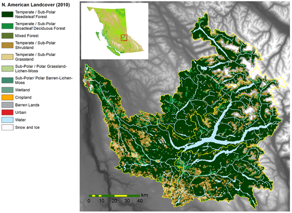
The following maps provide summaries of the watershed's topography, land-cover, ecological zones and geology. More information about the datasets from which they were derived is available on the page covering data support.

QRB topography, as depicted by the HydroSheds dataset
(Full-size version - 5.1 mb)

QRB land-cover, based on the North American Land Cover (2010)
(Full-size version - 1.6 mb)

QRB ecological zones, based on the BC Bio-geo-climatic Ecological Classification (BEC)
(Full-size version - 1.4 mb)

Principal geological units of the QRB, from the BC Geological Survey's BC Solid Geology spatial dataset.
(Full-size version - 1.9 mb)
Arsenault A. and Goward T. (1999) Ecological Characteristics of Inland Rain Forests Proc. Biology and Management of Species and Habitats at Risk, Kamloops, BC, 15-19 February 1999 pp. 437-440