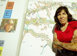
Research Unites Aboriginal Worldviews with State-of-the-Art Technology
August 3, 2005 for immediate release
A revolutionary system for combining Aboriginal perspectivesof the land with predominant techniques for mapping and resource management hasbeen developed by researchers at the University of Northern British Columbiaand the Halfway River First Nation. The development could usher in a new era ofAboriginal participation in resource management decision-making and communicationof traditional Aboriginal knowledge.
The new system is called a Geographic Valuation System (GVS)that incorporates traditional Aboriginal values and uses of the land into an Internet-based,multimedia application. From a computer-generated view of the landscape, clickableicons allow community users to access traditional knowledge associated withgeospatial data (latitude/longitude, wildlife habitat, roads, and rivers, etc).Halfway River has already catalogued traditional knowledge and uses indocuments, photos, audio clips, and videos and so far, more than 4000 of thesematerials (including 120 videos) are in the GVS. They can now be accessed bythe community for day-to-day decision-making.
“The GVS has at least two main advantages for our Nation,”says Halfway River Chief Roslyn Pokiak, who has been the community’s leadparticipant in the development of the system. “First, it will allow us toeffectively communicate with government and industry in discussions about thepotential effects of resource management decisions, such as the expansion ofoil and gas exploration. Secondly, and perhaps more importantly, it will be atool for educating our future generations about our traditional practices andmake our landscape literally come alive, even if some of the Elders who are capturedin photos or videos have already passed away.”
Joining Chief Pokiak in developing the GVS has been Alex Hawley, a professor in the UNBC EcosystemScience and Management program, and PhD student Nancy Elliot.
“The GVS enables Elders and other community members toparticipate in land use decisions, such as a proposal to establish a seismicline, without compromising their values. It also forms the foundation for an educational approach that fostersthe incorporation of traditional Aboriginal values in community development,” saysDr. Hawley. “It has been a challenge –and incredibly rewarding – to emphasize the oral tradition as a vital componentof land management processes. Our western map-making tradition has never been verysuccessful in doing this,” adds Nancy Elliot.
Halfway River First Nation has a population of 135 people onthe reserve, which is located 35km west of the Alaska Highway and about 90km northof Fort St. John. Their traditional lands coverone of northeastern BC’s richest oil and gas regions.
Contact:
Rob van Adrichem, Director of Media and Public Relations,UNBC – 250.960.5622